APPENDIX
1
NOTES ON PROCESSING AND QUALITY CONTROL
OF THE SEA SURFACE TEMPERATURE DATA
FROM THE METEOROLOGICAL OFFICE MAIN
MARINE DATA BANK (MOMMDB)
1. REMOVAL OF DUPLICATES (Figure 3 (in
main text), Box 1).
Observations originally entered the MOMMDB on punched cards or on data
sets keyed in 'card image' format. Any observation in a card batch or data
set was removed from the batch or data set if it was found to have all
80 columns identical with any other observation in that card batch or data
set: if there were 75 to 79 identical columns, the observation was printed
out for visual inspection and possible removal. When card batches or data
sets were being merged into the MOMMDB, observations identical to ones
already in MOMMDB were not added. The subsequent averaging of data for
1 deg. areas for individual pentads (Section 3(c) of the main text) will
have reduced the effects of undetected duplicates.
2. CREATION OF BACKGROUND FIELDS (Figures
4a, b, c, d (in main text))
(a) Formation of 'first guess' 1 deg. area background field averages
Accepted SAT or NMAT observations (Box 1 of Figure 4a) f or the whole
period of the record (1854-1981) were averaged, irrespective of the number
of observations in each contributing year, into a first-guess climatology
for each 1 deg. area and pentad (1-5 January etc.) (Box 2 of Figure 4a).
Away from the main shipping lanes, these averages were frequently based
on small samples of data, and in many 1 deg. areas an appreciable number
of pentads had no data.
When filling the gaps, the first step (Boxes 3 to 5 of Figure 4a, expanded
in Figure 4b) was to combine (without weighting) averages from consecutive
pentads in each 1 deg. area to produce up to 24 calendar 'half-monthly'
first guess values, using the mainly 3-pentad groupings in Table A1.1.
A single 4-pentad half month is required because there are 73 pentads in
a year: the period 2nd to 21st March was chosen for this because at this
time of the year SST usually changes only slowly with time, at least in
the northern hemisphere extratropics. A half-monthly value was permitted
to be formed from as little as a single pentad .
1 deg. areas that contained all possible calendar 'half-monthly' values
were defined as 'qualifying areas' (Box 2 of Figure 4b). If there were
fewer than four such 1 deg. areas in any 10 deg. area (Box 4 of Figure
4b), no background field was created for the 10 deg. area, except for a
few 10 deg. areas with more than about 3000 observations but with data
mostly missing at particular times of the year, e.g. some sub-arctic regions
with winter ice (Boxes 6 and 7 of Figure 4b). In these cases, a similar
selection of 'qualifying areas' was carried out using calendar 'monthly'
averages from pentads grouped as in Table A1.2 (Boxes 8 to 11 of Figure
4b).
(Table A1.1) Definition of calendar 'half-months' used
in the preliminary stages of creating the background fields
| Pentad numbers |
|
Dates |
Half-month
numbers |
| 1,2,3 |
1-15 |
January |
1 |
| 4,5,6 |
16-30 |
January |
2 |
| 7,8,9 |
31 |
January - 14 February |
3 |
| 10,11,12 |
15 |
February - 1 March
(in all years |
4 |
| 13,14 ,15,16 |
2-21 |
March |
5 |
| 17,18,19 |
22 |
March - 5 April |
6 |
| 20,21,22 |
6-20 |
April |
7 |
| . |
|
. |
. |
| . |
|
. |
. |
| . |
|
. |
. |
| 71,72,73 |
17-31 |
December |
24 |
(Table A1.2) Definition of calendar 'months' used in processing SST
and NMAT data from the MOMMDB
Month Pentads Calendar Equivalent
January 1-6 1-30 January February 7-12 31 January - 1 March (in all
years) March 13-18 2-31 March April 19-24 1-30 April May 25-30 1-30 May
June 31-36 31 May - 29 June July 37-42 30 June - 29 July August 43-49 30
July - 2 September September 50-55 3 September - 2 October October 56-61
3 October - 1 November November 62-67 2 November - 1 December December
68-73 2-31 December
(b) Smoothing of first guess 1 deg. area background field averages
to produce initial pentad 10 deg. area background field averages
For each qualifying 1 deg. area the 24 (or 12) first guess background
field averages were harmonically analysed (Box 6 of Figure 4a, expanded
in Figure 4c). The results were used to synthesize 1 deg. area calendar
pentad values, which varied smoothly in time. These values were averaged
to make a first estimate of the 10 deg. area background average for the
given pentad.
(c) Production of pentad 1 deg. area background field averages and
derived 5 deg. area monthly averages
The above calendar pentad 10 deg. area averages were combined with available
incomplete 1 deg. area calendar pentad background field averages from non-
qualifying 1 deg. areas within the same 10 deg. area, to complete initial
calendar pentad background field averages for these 1 deg. areas (Box 7
of Figure 4a, expanded in Figure 4d). This synthesis was, however, not
carried out for 1 deg. areas having fewer than four pentad averages (Figure
4d). The 1 deg. area calendar pentad background averages for the 10 deg.
area were then smoothed with the aid of timewise harmonic analysis and
synthesis. The results were re-analysed into sets of harmonic coefficients
(Boxes 8 to 10 of Figure 4a). However, some of the harmonic coefficients
were still found to fluctuate spatially by amounts exceeding the likely
real variations. Accordingly, each set of harmonic coefficients of a given
order was smoothed using a polynomial filter applied firstly to each of
the ten 1 deg. longitude bands and then to each of the ten 1 deg. latitude
bands (Box 11 of Figure 4a); the order of the polynomial was automatically
reduced if there were fewer than ten coefficients per row or column. This
could result from the presence of land or ice, or from 1 deg. areas being
absent because they had fewer than four original pentad values. The order
of the polynomial was five if there were ten or nine coefficients in the
row or column, four if there were only eight or seven coefficients, while
a third order polynomial was used if fewer than seven coefficients were
available. In this way all 1 deg. areas in processible 10 deg. areas were
provided with harmonic coefficients, from which a final set of background
1 deg. area calendar pentad averages was synthesized (Box 12 of Figure
4a). Background field values were derived for 5 deg. areas and calendar
months (as defined in Table A1.2) by averaging the appropriate 1 deg. area
calendar pentad values.
(d) Discussion of background fields
The calendar pentad 1 deg. area means were now smooth within any 10
deg. area, but some discontinuities across 10 deg. area boundaries required
smoothing. This was not done for the background field but the necessary
smoothing was incorporated at a later stage for SST when the MOMMDB-MIT
climatology was blended with the Alexander and Mobley climatology (see
Section 4 of this Appendix).
Near ice-edges, the annual cycle of the background field may have been
distorted by the limitation of SST and NMAT data to warmer than average
(i.e. ice-free) years, with consequent biases of the order of 0.5 deg.
C to 1 deg. C in the background field. Although systematic biases of this
size should have had much smaller biasing effects on the accuracy of later
stages of the procedure, similar problems are likely in the data used for
the final SST and NMAT climatologies.
3. QUALITY CONTROL FLAGS (Figure 3 (in
main text), Boxes 6 to 16)
(a) Range test (Figure 3 (in main text), Box 11)
In the range test, the standard deviation of all the winsorised monthly
mean anomalies available for a given 5 deg. area and calendar month was
calculated once and for all for the whole period 1854-1981. If the 5 deg.
area monthly mean anomaly for a given year lay outside the limit ±3 standard
deviations, the corresponding SST or NMAT value was flagged when archived
(b) Variance test (Figure 3, Box 13)
In the variance test, the pooled, weighted variance  2
of winsorised
pentad 1 deg. area values about their 5 deg. area mean was calculated for
the given calendar month using all years (1854-1981) where at least 16
such values were available. The weights were set proportional to the number
of 1 deg. area pentad values available in each year. Also calculated was
the variance 1 of the winsorised
set of 1 deg. area values for the
month and year under examination. When 1
exceeded the empirically-
chosen quantity 0.08n(2 + 1),
where n is the number of 1 deg. area
pentad values available in the year under test, that monthly 5 deg. area
value was flagged. This empirical expression was chosen, after large number
of experiments, to flag approximately 0.5% of those monthly 5 deg. area
values that were derived from 12 to 15 deg. area values, rising to 25%
of those monthly 5 deg. area values that were derived from only four 1
deg. area values.
2
of winsorised
pentad 1 deg. area values about their 5 deg. area mean was calculated for
the given calendar month using all years (1854-1981) where at least 16
such values were available. The weights were set proportional to the number
of 1 deg. area pentad values available in each year. Also calculated was
the variance 1 of the winsorised
set of 1 deg. area values for the
month and year under examination. When 1
exceeded the empirically-
chosen quantity 0.08n(2 + 1),
where n is the number of 1 deg. area
pentad values available in the year under test, that monthly 5 deg. area
value was flagged. This empirical expression was chosen, after large number
of experiments, to flag approximately 0.5% of those monthly 5 deg. area
values that were derived from 12 to 15 deg. area values, rising to 25%
of those monthly 5 deg. area values that were derived from only four 1
deg. area values.
4. BLENDING OF MOMMDB/MIT AND ALEXANDER AND
MOBLEY SST CLIMATOLOGIES
(a) Rationale
The climatology of Alexander and Mobley (1976) was used as a method
of filling the empty areas in the SST climatology mainly because it was
available in computer-compatible form. However, it is based on data for
a variety of periods earlier than 1951-80 (mainly 1920-60), so the temperatures
contained in it are probably negatively biased with respect to 1951-80
because of large-scale slow climatic changes (Folland, Parker and Kates
1984) Uncompensated changes of instrumentation may have caused an additional
overall negative bias, though these instrumental biases appear to be small
in the Southern Ocean (Section 3(h) of main text). Reynolds (1983) also
suggested that the Alexander and Mobley climatology has a winter bias to
lower temperatures that is greater than other climatologies. We therefore
merged the Alexander and Mobley climatology into the MOMMDB-MIT SST climatology
in such a way that the resulting values were as consistent as possible
with the MOMMDB-MIT climatology.
(b) Procedure
An MOMMDB-MIT 1 deg. area monthly SST climatology was produced by averaging
the constituent pentad values (see Box 8 of Figure 5 and Table A1.2). A
few modifications were made to the resulting climatology e.g. in the Sea
of Japan where the MOMMDB-MIT climatology had failed to represent adequately
the large west-east gradients, especially in winter. Revised values in
and around the Sea of Japan were derived using the 1951-80 climatology
of the Japan Meteorological Agency (1983) as a strong guide to the 'true'
climatology.
The following procedure achieved the goal of providing the empty areas
with an SST climatology that retained the patterns of geographical variation
contained in the Alexander and Mobley climatology but whose absolute values
were anchored as far as possible to those of the generally warmer and more
reliable MOMMDB-MIT climatology.
Empty areas of the MOMMDB-MIT climatology were filled in by solving
the following Poisson equation in spherical coordinates:
 2
2  =
2 A
=
2 A
where A is the Alexander and Mobley climatology (in a modified form
that resulted from timewise harmonic analysis and synthesis to ensure smooth
annual cycles) and is the resulting blended climatology
(Reynolds and Gemmill 1985). Thus, essentially, the spatial rates of change
of SST gradient in these areas of the MOMMDB-MIT climatology were set equal
to those in the modified Alexander and Mobley climatology. All SST values
were constrained to remain above -1.8 deg. C.
The solution of equation A1 is subject to internal and external boundary
conditions imposed by the MOMMDB-MIT SST values and by Alexander and Mobley's
SSTs along their ice limits. These ice limits are the only places where
Alexander and Mobley data are used in a direct way to produce the blended
field. However, their use is important as they will strongly influence
the derived blended values over much of the Southern Ocean because of the
great lack of MOMMDB-MIT data there. At lower latitudes MOMMDB-MIT data
become more plentiful and their influence on the blended solution predominates.
The blended 1 deg. area climatology was smoothed with a 1:2:1 filter,
first east-west and then north-south. This ensured that any residual 'jumps'
across 10 deg. area boundaries in the MOMMDB-MIT climatology (for instance
see Section 2(d) of this Appendix) were well-smoothed without affecting
SST gradients on >200 km scales.
5. DETERMINATION OF LAND/SEA/ICE CLASSIFICATION
FOR 5 deg. AREA CLIMATOLOGY
A 5 deg. area is defined to be land if and only if all 25 constituent
1 deg. areas are land. The 5 deg. area is ice if the number of ice 1 deg.
areas exceeds the number of sea 1 deg. areas. Otherwise the 5 deg. area
is sea.
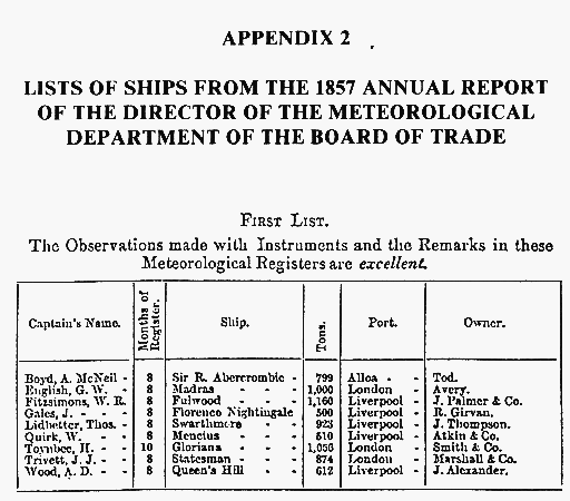
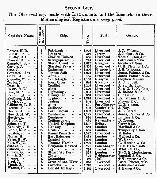
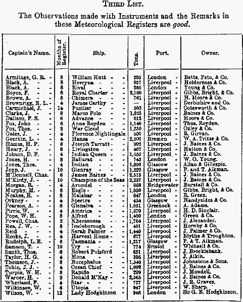
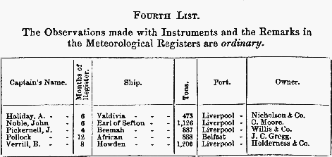
APPENDIX 2
LISTS OF SHIPS FROM THE 1857 ANNUAL
REPORT
OF THE DIRECTOR OF THE METEOROLOGICAL
DEPARTMENT OF THE BOARD OF TRADE
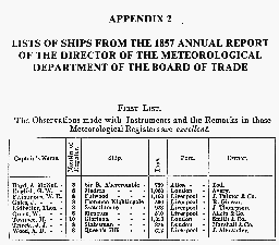
First list
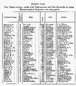
Second list
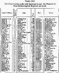
Third list
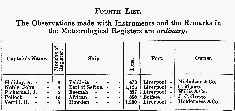
Fourth list
APPENDIX 3
LIST OF ABBREVIATIONS
| CDS |
Consolidated Data Set |
| COADS |
Comprehensive Ocean-Atmosphere Data Set |
| FNOC |
Fleet Numerical Oceanography Center (USA) |
| GOSTA |
Global Ocean Surface Temperature Atlas |
| GTS |
Global Telecommunication System |
| HMSO |
Her Majesty's Stationery Office (UK |
| ICSU |
International Council of Scientific Unions |
| IOC |
Intergovernmental Oceanographic Commission (of UNESCO) |
| LRFRR |
Long-Range Forecasting Research Report |
| MAT |
Marine Air Temperature |
| MIT |
Massachusetts Institute of Technology (USA) |
| MOMMDB |
Meteorological Office Main Marine Data Bank |
| NCAR |
National Center for Atmospheric Research (USA) |
| NMAT |
Night-time Marine Air Temperature |
| NOAA |
National Oceanic and Atmospheric Administration (USA) |
| SST |
Sea Surface Temperature |
| TDF |
Tape Data Family |
| UNESCO |
United Nations Educational Scientific and Cultural Organization |
| WCRP |
World Climate Research Programme |
| WMO |
World Meteorological Organization |